Unveiling the Mysteries of the Tartaria Map: A Comprehensive Exploration
The term “Tartaria Map” conjures images of a lost civilization, a forgotten empire, and a world vastly different from the one we know today. But what exactly is a Tartaria Map? Is it a historical artifact, a figment of imagination, or something in between? This article embarks on a comprehensive journey to explore the enigma of Tartaria Maps, delving into their origins, interpretations, and the enduring fascination they hold. We aim to provide clarity amidst the speculation, offering a balanced perspective grounded in available evidence and expert insights.
Deciphering the Enigma: What is a Tartaria Map?
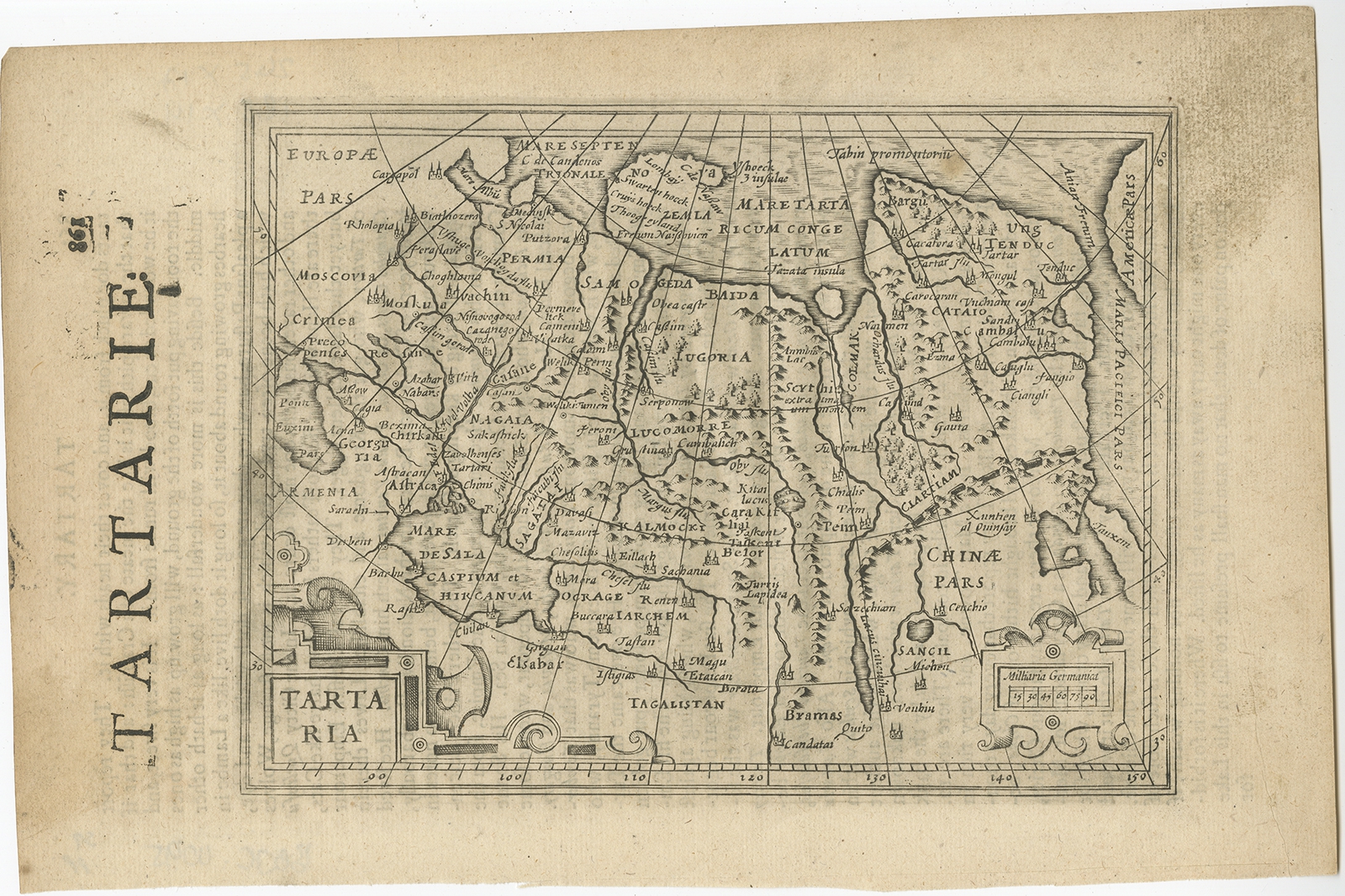
At its core, the term “Tartaria Map” typically refers to historical maps that depict a vast territory labeled “Tartary” or “Tartaria.” These maps, primarily produced by European cartographers from the 15th to the 19th centuries, showcase a region spanning across Central Asia, Siberia, and parts of Eastern Europe. The size and boundaries of Tartaria varied considerably across different maps, reflecting the limited and often inaccurate knowledge of the region at the time.
It’s crucial to understand that “Tartaria” was an exonym – a name given to a region by outsiders. It stemmed from the medieval perception of the Mongol Empire and its successor states, which exerted significant influence over these territories. The term “Tartar” itself was often used indiscriminately to refer to various nomadic groups and peoples inhabiting the Eurasian steppes.
The maps themselves were often compiled from a combination of travelers’ accounts, geographical surveys, and even folklore. Accuracy was not always a primary concern, particularly in the more remote and unexplored regions. As such, Tartaria Maps should be viewed as representations of European understanding (or misunderstanding) of Central Asia, rather than definitive records of a specific empire or civilization.
The Shifting Sands of Cartography: How Tartaria Maps Evolved
The depiction of Tartaria on maps underwent significant transformations over the centuries. Early maps often portrayed the region as a vast, sparsely populated land, inhabited by nomadic tribes. As European exploration and trade expanded eastward, more detailed information began to trickle in, leading to more refined (though not necessarily more accurate) representations.
By the 18th and 19th centuries, the name “Tartaria” gradually disappeared from most maps, as the region was incorporated into the expanding empires of Russia, China, and other powers. The term became increasingly obsolete, relegated to historical texts and scholarly discussions.
Distinguishing Fact from Fiction: Separating Historical Context from Modern Interpretations
The modern fascination with Tartaria Maps often extends beyond their historical context. In recent years, the term has become associated with alternative history theories, conspiracy narratives, and claims of a lost advanced civilization. These theories often interpret the maps as evidence of a technologically superior empire that was deliberately erased from mainstream history.
It is important to approach these interpretations with a critical eye. While the historical Tartaria was undoubtedly a complex and diverse region, there is no credible evidence to support claims of a global empire or advanced technology that has been systematically suppressed. Attributing advanced technological capabilities to Tartaria based solely on the presence of the name on old maps is a significant leap of logic.
The Allure of the Unknown: Why Tartaria Maps Captivate Us
Despite the lack of concrete evidence supporting alternative historical narratives, the allure of Tartaria Maps persists. Several factors contribute to this enduring fascination:
- The Mystery of the Unknown: Tartaria represents a region that was, for centuries, largely unknown and inaccessible to Europeans. This inherent mystery fuels speculation and imagination.
- The Appeal of Lost Civilizations: The idea of a lost, advanced civilization resonates with a deep-seated human desire to uncover hidden truths and challenge established narratives.
- The Power of Visual Representation: Maps, by their very nature, evoke a sense of authority and accuracy. The presence of “Tartaria” on historical maps lends credence to the idea that it was a significant entity.
- The Disconnect from Mainstream History: The relative obscurity of Tartaria in mainstream historical accounts makes it an appealing subject for those who question conventional narratives.
Exploring Related Historical Artifacts: A Broader Perspective
To fully understand the context of Tartaria Maps, it’s helpful to consider other related historical artifacts and sources. These include:
- Travelers’ Accounts: The writings of European travelers who ventured into Central Asia provide valuable insights into the region’s geography, cultures, and political landscape.
- Diplomatic Records: Documents relating to diplomatic missions and treaties between European powers and Central Asian rulers shed light on the interactions and perceptions of the time.
- Archaeological Discoveries: Archaeological excavations in Central Asia continue to uncover evidence of the region’s rich history and diverse civilizations.
- Historical Maps of Neighboring Regions: Examining maps of surrounding areas, such as China, Russia, and Persia, can provide a broader perspective on the geopolitical context of Tartaria.
Examining Map Projection Technologies: Understanding Cartographic Limitations
Modern cartography relies on sophisticated techniques to create accurate representations of the Earth’s surface. However, historical mapmakers faced significant limitations in terms of technology and data. One crucial aspect to consider is map projection.
Map projection is the process of transforming the three-dimensional surface of the Earth onto a two-dimensional plane. This process inevitably introduces distortions in shape, area, distance, or direction. Different map projections prioritize different properties, leading to varying representations of the world.
For example, the Mercator projection, commonly used in nautical charts, preserves angles and shapes but significantly distorts areas, particularly at higher latitudes. This distortion can lead to an exaggerated perception of the size of regions like Greenland and Siberia, which often fell within the boundaries of Tartaria.
Understanding the limitations of map projections is essential for interpreting historical maps accurately. It helps to avoid drawing unwarranted conclusions based on the visual appearance of geographical features.
Expert Analysis: Debunking Misconceptions About Tartaria Maps
Many misconceptions surround the interpretation of Tartaria Maps. Let’s address some of the most common ones:
- Misconception: Tartaria was a single, unified empire.
Reality: Tartaria was a broad, ill-defined region encompassing diverse ethnic groups and political entities. It was not a unified empire in the traditional sense. - Misconception: Tartaria possessed advanced technology that has been suppressed.
Reality: There is no credible evidence to support claims of advanced technology in Tartaria beyond what was typical for the time period. - Misconception: The disappearance of “Tartaria” from maps proves a deliberate cover-up.
Reality: The term simply fell out of use as the region was incorporated into other empires and more accurate geographical knowledge became available. - Misconception: All maps depicting Tartaria are accurate and reliable.
Reality: Historical maps are often inaccurate and reflect the limited knowledge and biases of their creators. They should be interpreted with caution.
Trustworthy Resources for Further Exploration: Where to Learn More
For those interested in delving deeper into the topic of Tartaria Maps, here are some trustworthy resources to consult:
- University Libraries and Archives: University libraries and archives often hold extensive collections of historical maps and documents.
- National Libraries and Archives: National libraries and archives, such as the Library of Congress and the British Library, are valuable resources for researching historical cartography.
- Scholarly Articles and Books: Academic journals and books on the history of cartography provide in-depth analysis and interpretation of historical maps.
- Reputable Online Databases: Online databases such as those provided by universities and museums can offer access to digitized historical maps.
The Enduring Legacy of Tartaria: A Reminder of Our Evolving Understanding of the World
While the historical reality of Tartaria may not align with the fantastical narratives that have emerged in recent years, the fascination with Tartaria Maps serves as a reminder of the evolving nature of our understanding of the world. These maps offer a glimpse into a time when vast regions remained shrouded in mystery, and cartographers relied on limited information and imaginative speculation to fill in the gaps.
By critically examining Tartaria Maps, we can gain a deeper appreciation for the challenges of historical cartography, the biases that can influence our perceptions of the world, and the enduring power of human curiosity to explore the unknown. Share your thoughts and discoveries about Tartaria maps in the comments below, and let’s continue to unravel this fascinating piece of our historical puzzle together.
